Where to Backpack in October When Winter Storms Are Rolling In
If the first snowstorm of the season hitting many mountain ranges around the country has you packing away your tent, airing out your sleeping bag and throwing your backpack into storage….hang on! Late fall is one of the best seasons for backpacking in certain parts of the country. Enjoy an extended backpacking season on one of these five backpacking trips across the American west, southwest and south.

White Rock Springs Loop, Superstition Wilderness, Arizona
This backpacking loop is located in Arizona’s Tonto National Forest in the Sonoran Desert. The White Rock Springs Loop offers unique rock formations, saguaro cacti, jumping cholla and expansive desert vistas. The route is a 23 mile figure eight shaped loop with 3,000 feet of elevation gain and is typically completed over 3 days. Backpackers set off from the First Water trailhead where there is a registration form to fill out on the way in - no permit or fee is required. The route requires using a network of different trails with many junctions so be sure to pre-download your navigation tool. Spend the first day hiking to the White Rock Springs area where backpackers set up camp at one of the nearby pre-established campsites. On day two, use camp as a home base and day hike an adjacent 10 mile loop trail. On day three, return to the trailhead on the southern half of the loop completed on day one. The Charlebois Springs a mile from camp is a reliable source of water but be sure to contact a National Forest ranger for a water report before hitting the trail. The trail is moderate difficulty with some loose, rocky climbs with endless trails in the area that can extend a trip if looking for a more challenging adventure.
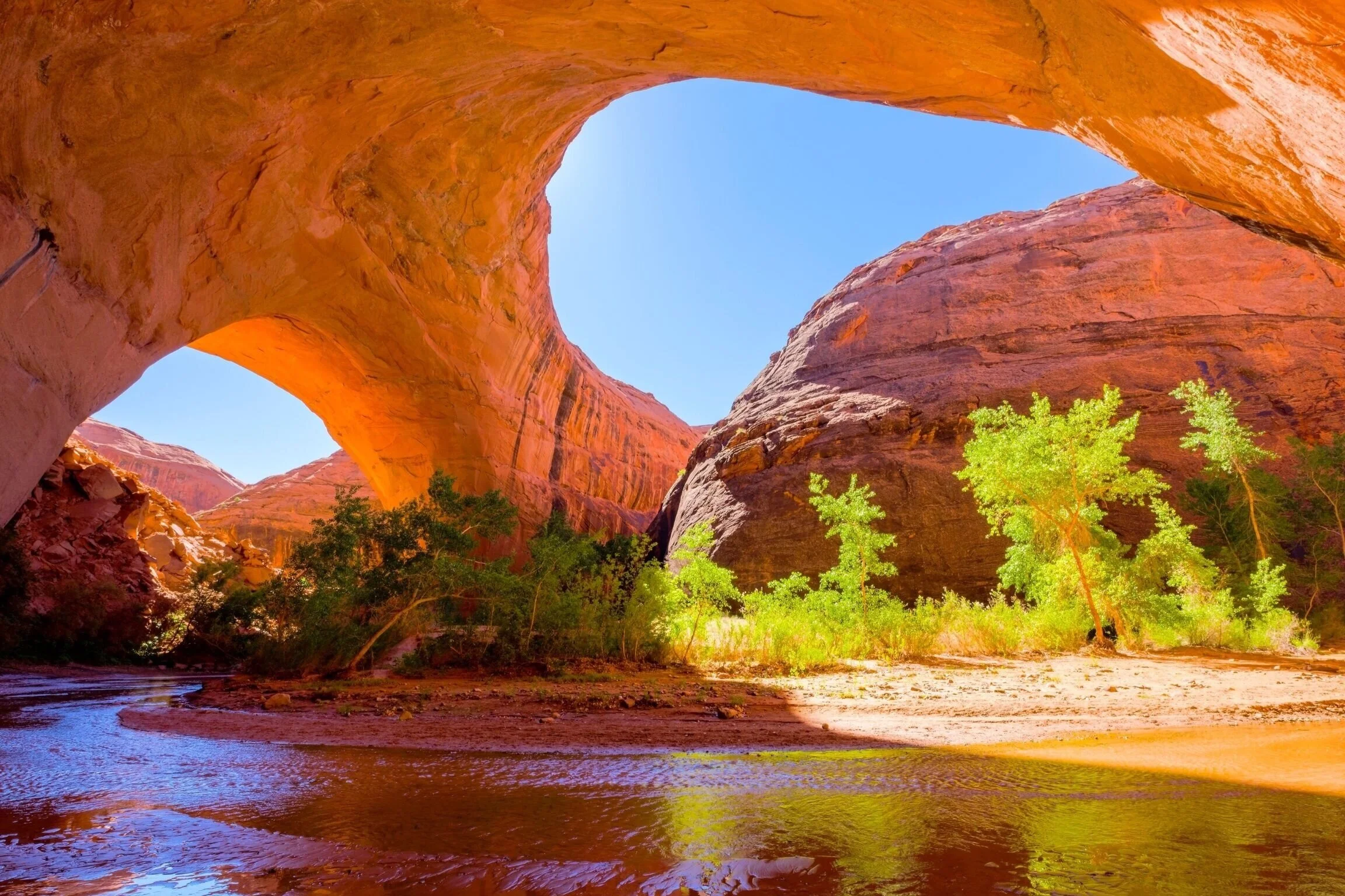
Coyote Gulch, Glen Canyon Recreation Area, Utah
Coyote Gulch is a famous slot canyon and bucket-list destination for many backpackers. It is dangerously hot in the summer months but come late fall the weather is perfect for a multi-day trip. The route traverses through towering red rock walls, soaring arches, natural bridges and canyon wetland. There are many different trailhead options for entering and exiting Coyote Gulch depending on desired route or distance so mileage varies considerably but the trip is typically completed over 2-4 days. The road which leads to the trailheads is called Hole-in-the-Rock Road and is unpaved washboard which requires patience and 4WD is recommended. Permits are required and can be picked up free of charge from the Escalante Interagency Visitor Center. There are reliable water sources available year-round in Coyote Gulch but the hike into and out of the area are dry. Be sure to pack or wear water shoes as much of the hike is through ankle deep water. Coyote Gulch is a slot canyon which means there is risk of flash flooding - discuss with a ranger while picking up permit and do not take a trip if rain is forecasted.
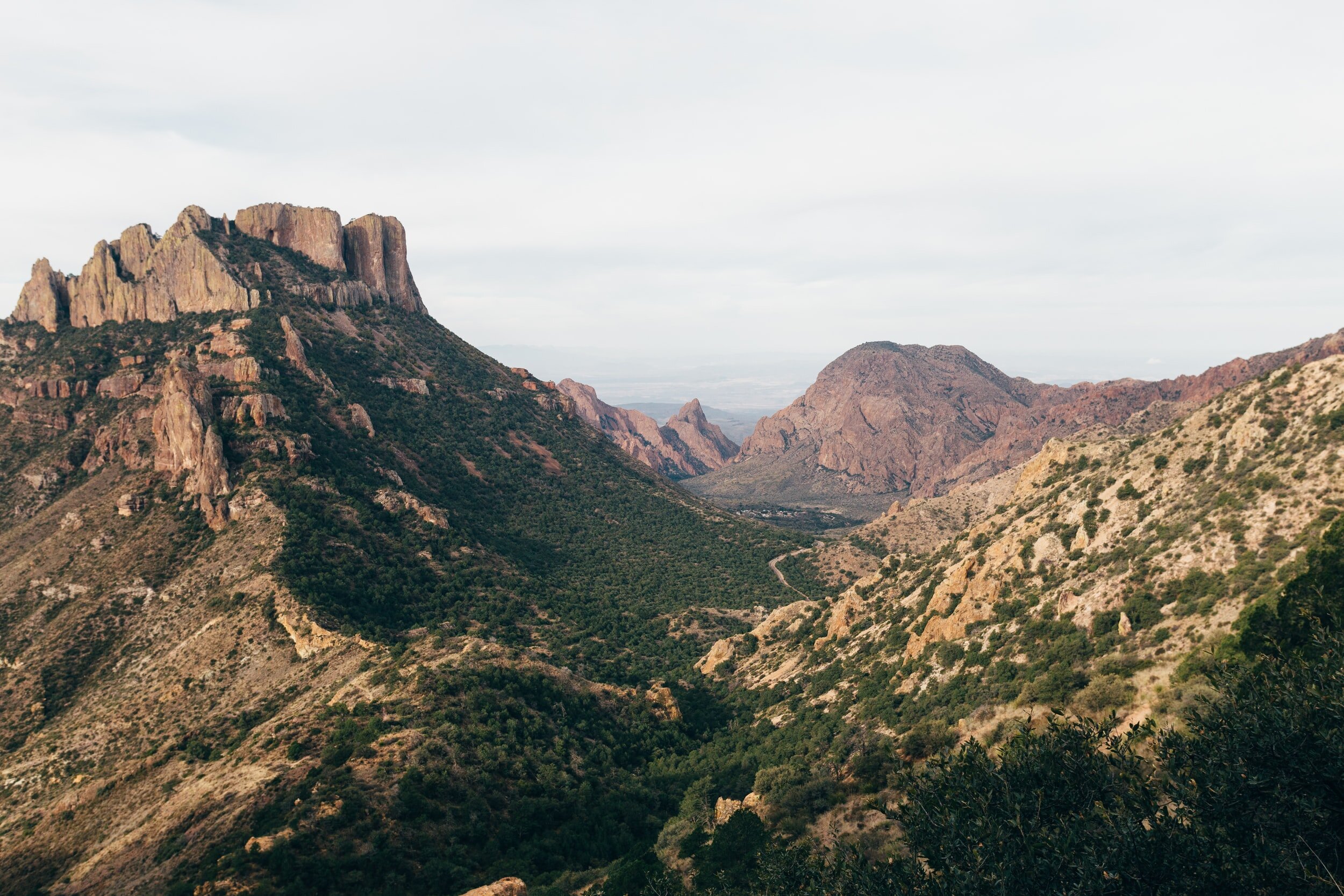
Outer Mountain Loop, Big Bend National Park, Texas
As temperatures drop in the fall Big Bend National Park becomes a much more hospitable destination for backpackers. The Outer Mountain Loop is a top backpacking trip in the park offering panoramic views of each of the varied environments the park is home to from the Chihuahua Desert floor to the high country of the Chisos Mountains. The loop is a 30 mile trip most commonly completed over 3 days. Day one sets off from the Chisos Basin trailhead heading clockwise through Chisos basin, Boot Canyon and Juniper Canyon. Day two continues through Juniper Canyon, along the Dodson Trail and into Blue Creek Canyon and the final day completes the journey through Blue Creek Canyon, Laguna Meadows and returns to Chisos Basin. Each day requires between 9-11 miles of hiking. The trip is considered difficult and should only be completed by experienced backpackers - there is a significant amount of elevation gain through desert terrain and no reliable water sources on trail. Backpackers will also need to cache water along the trail (Homer Wilson Ranch) before attempting the hike as it is too heavy to carry an entire water supply. Backcountry permits are required and can be picked up at any Big Bend Visitor Center up to 24 hours before a trip. The park is a designated International Dark Sky Park which means there is very little light pollution and it is an incredible place to sleep under the sparkling night skies.

Reflection Canyon, Glen Canyon Recreation Area, Utah
Reflection Canyon is a backpacking trip that leads to an iconic and rugged Utah viewpoint of Lake Powell. The route is an 18 mile out and back completed over 2 days. Backcountry permits are required and can be picked up at the Escalante Interagency Visitor Center en route to the trailhead. The Reflection Canyon trailhead is an unmarked parking area located 50 miles down Hole-in-the-Rock Road which is a gravel washboard road which turns into quite the rocky, remote adventure a few miles out from the trailhead (4WD and high clearance recommended). The trip is rated difficult due to full exposure to sun, off-trail navigation and lack of water sources on trail. The majority of the route is along a faint dirt path and low lying brush but the last few miles transitions into slickrock and it becomes challenging to stay on course. The up and down and constant route finding can be quite strenuous but it will feel more than worth it when the first glimpse of winding blue waters and towering orange cliffs come into view. Sunrise in this spot will be a memory you will never forget.

Cottonwood-Marble Canyon Loop, Death Valley National Park, California
The Cottonwood-Marble Canyon Loop is a 31-mile backpacking trip that loops through two canyons in Death Valley National Park. This loop features beautiful desert landscapes, dramatic canyons, wide-open wilderness and if you get lucky, wild horses galloping in the distance. Death Valley is the hottest place on earth but by late fall temperatures become much more reasonable for backpacking. Backpackers set off from the intersection of Cottonwood Canyon Road and Marble Canyon Road completing the loop clockwise and typically need 2-4 days. A free backcountry permit must be picked up at a ranger station before heading to the starting point and a vehicle with 4WD is recommended as the road is a rocky wash with sand, gravel and tight corners. The loop is rated as difficult and recommended for experienced backpackers as it requires strong navigation (majority cross-country travel), water sources are seasonal (unreliable in the fall), provides little shade and requires 3,800+ feet of climbing. Flash floods can also be incredibly dangerous on this route so be sure to check the forecast and discuss with a ranger before the trip.
It is important to note all 5 trips are located in rugged desert terrain. Desert climates often mean unrelenting temperatures and sun exposure, limited or no water sources and monsoons or flash flooding. Severe dehydration, heat exhaustion or heat stroke occur frequently in these areas. Stay well hydrated, replenish electrolytes, hike during the coolest parts of the day and make certain you can recognize the signs of heat illness. Complete extensive research on current water sources, navigation and weather forecast and connect with a local ranger before setting off.